
File:Церковь Сурб Карапет (Ростовская область, село Несветай).jpg

Size of this preview: 800 × 520 pixels. Other resolutions: 320 × 208 pixels | 640 × 416 pixels | 1,024 × 666 pixels | 1,280 × 833 pixels | 2,560 × 1,665 pixels | 4,034 × 2,624 pixels.
Original file (4,034 × 2,624 pixels, file size: 2.6 MB, MIME type: image/jpeg)
| This is a file from the Wikimedia Commons. Information from its description page there is shown below. Commons is a freely licensed media file repository. You can help. |
.jpg)
Summary
| Description |
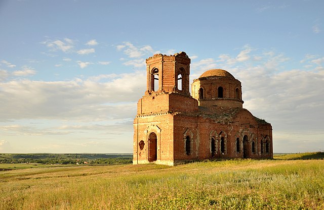
Русский: Армянская церковь Сурб Карапета (Святого Карапета, Иоанна Предтечи) в селе Несветай,Мясниковский район,Ростовская область, Россия. Построена в 1892 году по проекту таганрогского архитектора Н. Муратова. English: Church of Surp Garabed (St. Garabed, John the Baptist) in the village Nesvetay, Myasnikovsky District, Rostov Oblast, Russia. Built in 1892, designed by architect N. Muratov
|
||||
| Date | |||||
| Source | Own work | ||||
| Author | Жанетта Багаджиян |
| Camera location | | View this and other nearby images on: OpenStreetMap |
|---|
.jpg¶ms=047.452618_N_0039.664231_E_globe:Earth_type:camera__&language=en)
Licensing
I, the copyright holder of this work, hereby publish it under the following license:
This file is licensed under the Creative Commons Attribution-Share Alike 3.0 Unported license.
- You are free:
- to share – to copy, distribute and transmit the work
- to remix – to adapt the work
- Under the following conditions:
- attribution – You must give appropriate credit, provide a link to the license, and indicate if changes were made. You may do so in any reasonable manner, but not in any way that suggests the licensor endorses you or your use.
- share alike – If you remix, transform, or build upon the material, you must distribute your contributions under the same or compatible license as the original.

|
This image was uploaded as part of Wiki Loves Monuments 2013.
|
File history
Click on a date/time to view the file as it appeared at that time.
| Date/Time | Thumbnail | Dimensions | User | Comment | |
|---|---|---|---|---|---|
| current | 11:43, 28 September 2013 | | 4,034 × 2,624 (2.6 MB) | Zhanett.b | User created page with UploadWizard |
File usage
The following pages on the English Wikipedia use this file (pages on other projects are not listed):
Global file usage
The following other wikis use this file:
- Usage on ar.wikipedia.org
- Usage on arz.wikipedia.org
- Usage on ceb.wikipedia.org
- Usage on fr.wikipedia.org
- Usage on hy.wikipedia.org
- Usage on ka.wikipedia.org
- Usage on ru.wikipedia.org
- Usage on ru.wikimedia.org
- Usage on ru.wikinews.org
- Usage on ru.wikivoyage.org
- Usage on www.wikidata.org
.jpg)