
File:September 2020 Nagorno-Karabakh clashes RU.png
No higher resolution available.
September_2020_Nagorno-Karabakh_clashes_RU.png (595 × 387 pixels, file size: 22 KB, MIME type: image/png)
| This is a file from the Wikimedia Commons. Information from its description page there is shown below. Commons is a freely licensed media file repository. You can help. |
Summary
| Description |
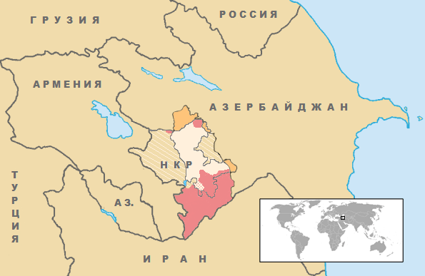
English: Location of 2020 Nagorno-Karabakh clashes, per the public information provided by the Azerbaijani MoD. In Russian |
| Date | |
| Source | Location Artsakh en.png |
| Author | en:User:VartanM. World inset added by en:User:Kmusser. Location of clashes added by en:User:Interfase. |
Licensing
| This file is made available under the Creative Commons CC0 1.0 Universal Public Domain Dedication. | |
| The person who associated a work with this deed has dedicated the work to the public domain by waiving all of their rights to the work worldwide under copyright law, including all related and neighboring rights, to the extent allowed by law. You can copy, modify, distribute and perform the work, even for commercial purposes, all without asking permission.
|
| Annotations | This image is annotated: View the annotations at Commons |
File history
Click on a date/time to view the file as it appeared at that time.
| Date/Time | Thumbnail | Dimensions | User | Comment | |
|---|---|---|---|---|---|
| current | 07:13, 13 December 2020 | | 595 × 387 (22 KB) | Nicolay Sidorov | This map concerns the fighting from 27.09.2020 to 10.11.2020 and the signed agreement. Any further conflicts and boundary changes do not apply to this map |
| 16:21, 12 December 2020 |  | 595 × 387 (77 KB) | Mastersun25 | Chailakgaya (Khtsaberd) and Kehnya Taglar (Hin Taher) recaptured by Azerbaijan https://caucasus.liveuamap.com/en/2020/12-december-both-villages-in-the-hadrut-region-chailakgaya | |
| 20:14, 2 December 2020 |  | 595 × 387 (22 KB) | Nicolay Sidorov | There is not Khtsaberd and Hin Taker under azeri control | |
| 12:32, 11 November 2020 |  | 595 × 387 (77 KB) | Constantzeanu | uploading updated map as per this source https://caucasus.liveuamap.com/ | |
| 17:25, 10 November 2020 |  | 595 × 387 (71 KB) | Interfase | + 3 villages of Lachin district announced on 9 November: Gulebird, Safyan and Turklar | |
| 15:32, 10 November 2020 |  | 595 × 387 (78 KB) | Constantzeanu | I think if we want to depict the map as it is described in the agreement, we also have to indicate the areas which Armenia has to return to Azerbaijan by December 1st, depicted here in the hashed area. | |
| 01:15, 10 November 2020 |  | 595 × 387 (67 KB) | Parishan | + Shusha | |
| 11:58, 7 November 2020 |  | 595 × 387 (67 KB) | Interfase | + villages of Zangilan, Fuzili, Khojaly and Khojavend announced on 7 November 2020 | |
| 07:55, 6 November 2020 |  | 595 × 387 (66 KB) | Interfase | + villages of Qubadli and Zangilan the liberation announced on 2 and 4 November 2020 | |
| 19:58, 30 October 2020 |  | 595 × 387 (71 KB) | Interfase | + 3 villages of Qubadli district announced today |
File usage
No pages on the English Wikipedia use this file (pages on other projects are not listed).
Global file usage
The following other wikis use this file:
- Usage on be.wikipedia.org
- Usage on es.wikipedia.org
- Usage on hu.wikipedia.org
- Usage on pt.wikipedia.org
- Usage on ru.wikipedia.org
- Usage on tg.wikipedia.org
- Usage on uz.wikipedia.org
- Usage on www.wikidata.org