
Portal:Western Australia
Introduction
 Western Australia (commonly abbreviated as WA) is a state of Australia occupying the western third of the land area of Australia, excluding external territories. It is bounded by the Indian Ocean to the north and west, the Southern Ocean to the south, the Northern Territory to the north-east, and South Australia to the south-east. With a total land area of 2,527,013 square kilometres (975,685 sq mi), Western Australia is Australia's largest state as well as the second-largest subdivision of any country on Earth, surpassed only by the Sakha Republic in eastern Russia. the state has 2.76 million inhabitants—11 percent of the national total. The vast majority (92 percent) live in the south-west corner; 79 percent of the population lives in the Perth area, leaving the remainder of the state sparsely populated. The first Europeans to visit Western Australia belonged to the Dutch Dirk Hartog expedition, who visited the Western Australian coast in 1616. The first permanent European colony in what is today Western Australia occurred following the landing by Major Edmund Lockyer on 26 December 1826 of an expedition on behalf of the New South Wales colonial government. Lockyer established a convict-supported military garrison at King George III Sound, at present-day Albany, and on 21 January 1827 he formally took possession for the British Crown of the western part of the continent that was not already claimed by the Crown. This was followed by the establishment of the Swan River Colony in 1829, including the site of the present-day capital, Perth. (Full article...)
|


.jpg)


(Northern
Territory) |
 Good articles -
-
 The GST distribution dispute is an ongoing political controversy concerning the distribution of goods and services tax (GST) revenue amongst the Australian states and territories and the federal government. The dispute was originally based upon Western Australia's (WA) dissatisfaction with its low returns, which led to reform in 2018. The 2018 reform guarantees all states and territories a minimum return on their contribution.
As a result of WA's improved financial position during and after the COVID-19 pandemic, debate has since centred around the suitability of the minimum payments floor introduced. Currently, the federal government provides a "no worse-off guarantee", meaning that states and territories receive either the funding they would have under the old system or the new system, whichever is higher. This prevents the reform causing disadvantage to any jurisdiction during the transition period, which will expire in 2029–30. Several states have held inquiries and have alternatively demanded the federal government undo the reform or continue contributing to the GST pool. Criticism has also been levelled at the expenses the federal government incurs subsidising states under the no worse-off guarantee. (Full article...) -

Operation Mosaic was a series of two British nuclear tests conducted in the Montebello Islands in Western Australia on 16 May and 19 June 1956. These tests followed the Operation Totem series and preceded the Operation Buffalo series. The second test in the series was the largest ever conducted in Australia.
The purpose of the tests was to explore increasing the yield of British nuclear weapons through boosting with lithium-6 and deuterium, and the use of a natural uranium tamper. Although a boosted fission weapon is not a hydrogen bomb, which the British Government had agreed would not be tested in Australia, the tests were connected with the British hydrogen bomb programme. (Full article...) -
The history of Fremantle Prison, a former Australian prison in Fremantle, Western Australia, extends from its construction as a prison for convicts, using convict labour, in the 1850s, through to its modern-day usage as a tourist attraction. The design for Fremantle Prison was based on the Pentonville Prison in Britain, and it would be the longest, tallest prison cell block in the southern hemisphere. Construction began in 1851, and was completed by the end of 1859. The prison was transferred to the colonial government in 1886 for use for locally sentenced prisoners. Following a Royal Commission held in 1898−99, some changes were made to Fremantle Prison, including knocking down the inner wall between two cells, introducing a prisoner classification system, and constructing internal walls in the main block to create four separate divisions. A new cell block, New Division, was completed in 1907 and occupied in 1908.
Following another Royal Commission investigation 1911, there were some rapid changes in prison policy. A new superintendent with outside experience, Hugh Hann, was appointed, and supported by the newly elected Labor government interested in penal reform. Fremantle Prison was partially used as a military gaol during both world wars. The World War II takeover necessitated the commissioning of Barton's Mill Prison in 1942, which remained opened after the war. Pardelup Prison Farm was another prison outstation established in 1927 to reduce overcrowding at Fremantle. Both facilities were part of reforms made to the prison system, but significant changes to the operation of Fremantle Prison did not begin until the 1960s. Comptroller General Colin Campbell introduced expedient prisoner assessments, officer training, work release programs, and social workers and welfare officers. (Full article...) -
Bayswater is a suburb 6 kilometres (4 mi) north-east of the central business district (CBD) of Perth, the capital of Western Australia. It is just north of the Swan River, within the City of Bayswater local government area. It is predominantly a low-density residential suburb consisting of single-family detached homes. However, there are several clusters of commercial buildings, most notably in the suburb's town centre, around the intersection of Whatley Crescent and King William Street and a light industrial area in the suburb's east.
Prior to European settlement, the Mooro group of the Whadjuk Noongar people inhabited the area. In 1830, the year after the European settlement of the Swan River Colony, land along the river was divided between the colonists, who moved in soon after. Most either died or left in the months following, leaving the area undeveloped for most of the 19th century. In 1881, the Fremantle–Guildford railway line was built, triggering the founding of the Bayswater Estate, the first development in the area, and in 1897, the Bayswater Road Board was founded, giving Bayswater its own local government. At first, development consisted of nurseries, market gardens and dairies, but as time went on, Bayswater became more and more suburban. Today, Bayswater is fully suburbanised, with the subdividing of older lots being commonplace. Plans for apartments around Bayswater and Meltham railway stations are a contentious issue. (Full article...) -
Bayswater railway station is a suburban rail station in Bayswater, a suburb of Perth, Western Australia. It is the junction station for Transperth's Midland and Airport lines, and the Morley–Ellenbrook line when it opens in late 2024.
The station first opened in 1896 on the Perth to Midland railway with two side platforms and an adjacent goods yard. It served as the junction station for the Belmont spur line between 1896 and 1956. Bayswater station was rebuilt as an island platform just to the north in the late 1960s when the Midland line was converted from narrow gauge to dual gauge; the standard gauge trains were unable to fit between the side platforms. Around that time, the goods yard closed. (Full article...) -

The 2010 Gascoyne River flood was regarded as the most severe flood to take place along the Gascoyne River in Western Australia on record. Triggered by record-breaking rainfall, amounting to over 6,000 percent of the monthly mean, 313.6 mm (12.35 in) and 5 mm (0.20 in) respectively, in just four days, the floods caused widespread damage in the region. By 17 December, the river began to rise in response to the heavy rains, eventually exceeding its banks within two days. Water levels reached record values at three stations along the river, cresting at 15.53 m (51.0 ft) near Fishy Pool. Evacuation orders were issued for several towns affected by rising waters. The most substantial impact was felt in Carnarvon where entire homes were washed away. Following the disaster, emergency supplies and funds were distributed to affected residents to aid them in restoring their livelihoods. Though no people died in the event, an estimated two thousand head of cattle perished and damage was estimated at A$100 million. (Full article...) -
Tropical Cyclone Alessia was the first tropical cyclone to affect the Northern Territory of Australia in November since Cyclone Joan in 1975. The storm was first identified as a tropical low on 20 November 2013 well to the northwest of Australia. Tracking generally west to west-southwest, the small system steadily organized into a tropical cyclone by 22 November. Maintaining a small central dense overcast, Alessia brushed the Kimberley region before making landfall in the Top End region with winds of 65 km/h (40 mph) on 23 and 24 November respectively. Some weakening took place as the system moved over land; however, reorganization occurred as it neared the Gulf of Carpentaria. After moving over water on 26 November, it redeveloped gale-force winds. Alessia reached its peak intensity on 27 November with winds of 85 km/h (53 mph) and a barometric pressure of 991 mbar (hPa; 29.26 inHg) and subsequently made its final landfall near Wollogorang. Weakening ensued once more as the storm traveled over land; though, Alessia's remnants looped eastward back over water before doubling back to the west. The system was last noted moving inland again over the Northern Territory on 1 December.
Throughout Alessia's existence, it caused only minimal damage. Several areas experienced gale-force winds, with gusts measured up to 109 km/h (68 mph) on Centre Island. Moderate to heavy rains accompanied the system as well, with a storm maxima of 290.4 mm (11.43 in) also occurring on Centre Island. (Full article...) -
Collier Road is a 4.7-kilometre (2.9 mi) main road in the north-eastern suburbs of Perth, Western Australia, linking Morley in the north-west to Bassendean in the south-east. It services an industrial area in Bayswater and Bassendean, the Morley business district, and connects to Tonkin Highway. Collier Road first existed as a gravel track in the 1910s. The 1950s and 1960s saw the land around Collier Road change from rural to urban. It has undergone a major realignment twice, first in the mid-1980s to make room for a larger shopping centre in Morley, and between 2016 and 2018, for the construction of an interchange with Tonkin Highway. (Full article...) -
Bedford is a suburb 6 kilometres (4 mi) north-east of the central business district (CBD) of Perth, the capital of Western Australia. Named after Frederick Bedford, the Governor of Western Australia from 1903 to 1909, the suburb is within the City of Bayswater local government area. It is predominantly a low density residential suburb consisting of single-family detached homes, with clusters of commercial buildings along Beaufort Street, Grand Promenade and Walter Road.
Before European settlement, the area was inhabited by the Mooro group of the Whadjuk Noongar people. The first major developments for the suburb occurred in the 1920s, when the extension of Beaufort Street and its associated tram service into the area triggered housing construction. Bedford Park was gazetted as a townsite in 1937, and major growth occurred following World War II, due to developments by the State Housing Commission. Today, Bedford is fully suburbanised. (Full article...) -
North West Coastal Highway is a generally north-south Western Australian highway which links the coastal city of Geraldton with the town of Port Hedland. The 1,300-kilometre-long (808 mi) road, constructed as a sealed two-lane single carriageway, travels through remote and largely arid landscapes. Carnarvon is the only large settlement on the highway, and is an oasis within the harsh surrounding environment. The entire highway is allocated National Route 1, part of Australia's Highway 1, and parts of the highway are included in tourist routes Batavia Coast Tourist Way and Cossack Tourist Way. Economically, North West Coastal Highway is an important link to the Mid West, Gascoyne and Pilbara regions, supporting the agricultural, pastoral, fishing, and tourism industries, as well as mining and offshore oil and gas production.
In Geraldton, the highway begins at a grade separated interchange with Brand Highway and roads providing access to the port and town centre. Two major roads link the North West Coastal Highway to the inland Great Northern Highway: Geraldton–Mount Magnet Road in Geraldton, and Nanutarra Munjina Road at Nanutarra, 845 kilometres (525 mi) further north. Several roads link provide access to coastal towns and attractions, including Shark Bay Road, Onslow Road and Karratha Road. With few towns on the highway, roadhouses are the only settlements for long stretches. North West Coastal Highway ends at Great Northern Highway, 30 kilometres (19 mi) out from Port Hedland. (Full article...) -

Aerial view of Fremantle Prison (1935)
The architecture of Fremantle Prison includes the six-hectare (15-acre) site of the former prison on The Terrace, Fremantle, in Western Australia. Limestone was quarried on-site during construction, and the south-western corner (the South Knoll) and eastern portion of the site are at a considerably higher ground level. The Fremantle Prison site includes the prison cell blocks, gatehouse, perimeter walls, cottages, tunnels, and related infrastructure.
The Main Cell Block is the longest and tallest cell range in Australia, and a dominating feature of the prison. New Division, constructed between 1904 and 1907, continues the façade alignment of the main block. Service buildings were converted into the separate Women's Prison. Fremantle Prison is surrounded by limestone perimeter walls, while a two-storey limestone gatehouse, with a central clock, presents an imposing entrance. North and south of the gatehouse, on The Terrace, are several cottages and houses – three of which are built in Victorian style in contrast to the Georgian style of the others. (Full article...) -
Victoria Park railway station is a suburban railway station on the Transperth network in Western Australia. The station is in the Perth suburbs of Lathlain and Victoria Park. Since November 2023, the station has been the terminus of the Armadale and Thornlie lines due to the Victoria Park-Canning Level Crossing Removal Project. The whole of each line is expected to reopen in mid-2025.
The first Victoria Park station opened in 1898 after lobbying by the Municipality of Victoria Park. It gained a station master in 1922, which lasted until 1969. The Victoria Park section of the Armadale line underwent several improvements in the 2000s. Lathlain station closed in 2003, and a nearby level crossing was removed and replaced with a bridge. The Thornlie line commenced services on 7 August 2005, enabling most Armadale services to skip the station. In 2007, construction started on a new Victoria Park station, 230 metres (750 ft) south of the original station and closer to the demolished Lathlain station. The new station had greater accessibility and was no longer on a curve, which allowed for a smaller platform gap. The new Victoria Park station opened on 2 August 2008, and the old one was demolished soon afterwards. (Full article...) -
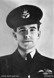
Air Commodore Sir Hughie Idwal Edwards, VC, KCMG, CB, DSO, OBE, DFC (1 August 1914 – 5 August 1982) was a senior officer in the Royal Air Force, Governor of Western Australia, and an Australian recipient of the Victoria Cross, the highest decoration for gallantry "in the face of the enemy" that can be awarded to members of the British and Commonwealth armed forces. Serving as a bomber pilot in the Royal Air Force (RAF), Edwards was decorated with the Victoria Cross in 1941 for his efforts in leading a bombing raid against the port of Bremen, one of the most heavily defended towns in Germany. He became the most highly decorated Australian serviceman of the Second World War.
Born in Fremantle, Western Australia, Edwards joined the Royal Australian Air Force in 1935, and a year later was granted a short service commission with the RAF. Serving throughout the Second World War, he gained a permanent commission and continued his career in the RAF after the war; he retired in 1963 with the rank of air commodore. Returning to Australia, he was appointed Governor of Western Australia in 1974. (Full article...) -
Nicolas Pierre Goiran (born 15 October 1977) is an Australian politician who has been a member for the South Metropolitan Region of the Western Australian Legislative Council (MLC), the upper house of the Parliament of Western Australia, since 22 May 2009.
A member of the Liberal Party, Australia's major centre-right political party, Goiran is a conservative Christian. He is pro-life, and opposes same-sex marriage, euthanasia and surrogacy. He has been outspoken on the issue of elder abuse, and he supports COVID-19 vaccinations but opposes COVID-19 vaccine mandates. Goiran has twice been accused of filibustering: he spoke for over 22 hours in total over a surrogacy bill in 2019, delaying it; and he proposed 357 amendments to a voluntary assisted dying bill and spoke on every clause of the bill. (Full article...) -
Severe Tropical Cyclone Rosita was a tropical cyclone that affected northern Australia from 15 April through 21 April 2000. Rosita was one of the most intense tropical cyclones to hit the west Kimberley coast in the last century. Crossing the coast as a Category 5 about 40 kilometres (25 mi) south of Broome on 20 April, Rosita caused severe damage in the Eco Beach resort and the vegetation around Broome. Its region of very destructive winds (gusts exceeding 170 km/h) passed south of Broome by only 15 kilometres (9.3 mi). Cyclone Rosita was the first cyclone to directly hit Broome since Cyclone Lindsay in March 1985. (Full article...)


_(cropped).png)


Did you know (auto-generated)

- ... that Mertome Village in Bayswater, Western Australia was the first aged care complex to be built by a local government in Australia?
- ... that Western Australia was the second Australian state to legalise voluntary assisted dying?
- ... that the search for a lost radioactive capsule along a 1,400-kilometre (870 mi) stretch of road in Western Australia was likened to looking for a needle in a haystack?
- ... that politician John D'Orazio helped to secure a three-year trial of daylight saving time in Western Australia?
- ... that Nick Goiran, a member of the Western Australian Legislative Council, proposed 357 amendments to a voluntary assisted dying bill?
- ... that Bill Dunn, an Indigenous Australian pastoralist approaching retirement, sold his station at half-price to the Jigalong community despite receiving full-price offers from non-Indigenous people?
Categories

More portals
More did you know...

- ...that when the 1987 America's Cup was raced off Fremantle, Western Australia it was the first time for 132 years that the regatta had not been hosted by the New York Yacht Club?
- ...that the original Victoria Dam, constructed in 1891, was the first dam in Western Australia, and it stood for almost 100 years before being replaced with the current dam?
- ...that Anglican bishop Kay Goldsworthy was consecrated as the first woman bishop of any Australian church on 22 May 2008?
Related WikiProjects

Things you can do
Here are some tasks you can do to help with WikiProject Western Australia:
Associated Wikimedia
The following Wikimedia Foundation sister projects provide more on this subject:
-
 Commons
Free media repository -
 Wikibooks
Free textbooks and manuals -
 Wikidata
Free knowledge base -
 Wikinews
Free-content news -
 Wikiquote
Collection of quotations -
 Wikisource
Free-content library -
 Wikispecies
Directory of species -
 Wikiversity
Free learning tools -
 Wikivoyage
Free travel guide -
 Wiktionary
Dictionary and thesaurus


