
Lost Wilson Mountain
| Lost Wilson Mountain | |
|---|---|
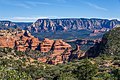
 West aspect (from Bear Mountain) | |
| Highest point | |
| Elevation | 6,762 ft (2,061 m)[1] |
| Prominence | 342 ft (104 m)[1] |
| Parent peak | Wilson Mountain (7,122 ft)[1] |
| Isolation | 1.79 mi (2.88 km)[1] |
| Coordinates | 34°55′44″N 111°46′46″W / 34.9288998°N 111.7793138°W[2] |
| Naming | |
| Etymology | Richard Wilson |
| Geography | |
 Lost Wilson Mountain Location in Arizona  Lost Wilson Mountain Lost Wilson Mountain (the United States) | |
| Country | United States |
| State | Arizona |
| County | Yavapai |
| Protected area | Red Rock-Secret Mountain Wilderness |
| Parent range | Colorado Plateau[3] |
| Topo map | USGS Wilson Mountain AZ |
| Geology | |
| Age of rock | Permian |
| Type of rock | Basalt Coconino Sandstone Schnebly Hill Formation |
Lost Wilson Mountain is a 6,762-foot-elevation (2,061-meter) summit in Yavapai County, Arizona, United States.
Description[edit]
Wilson Mountain is located four miles north of Sedona in the Red Rock-Secret Mountain Wilderness, on land managed by Coconino National Forest. It is the third-highest peak in the wilderness.[1] The summit lies within Yavapai County, whereas the eastern half of this landform is within Coconino County.[2] Precipitation runoff from this mountain drains into the Oak Creek watershed. Topographic relief is significant as the summit rises 1,760 feet (536 meters) above Sterling Canyon in 0.6 mile (1 km). The nearest higher neighbor is Wilson Mountain, 1.79 miles (2.88 km) to the southeast.[3] The mountain's toponym has been officially adopted by the United States Board on Geographic Names.[2]
Climate[edit]
According to the Köppen climate classification system, Lost Wilson Mountain is located in a temperate semi-arid climate zone.[4] Climbers can expect afternoon rain and lightning from the seasonal monsoon in late July and August.
See also[edit]
References[edit]
- ^ a b c d e "Lost Wilson Mountain - 6,762' AZ". listsofjohn.com. Retrieved 2024-05-12.
- ^ a b c "Lost Wilson Mountain". Geographic Names Information System. United States Geological Survey, United States Department of the Interior. Retrieved 2024-05-12.
- ^ a b "Lost Wilson Mountain, Arizona". Peakbagger.com. Retrieved 2024-05-12.
- ^ Peel, M. C.; Finlayson, B. L.; McMahon, T. A. (2007). "Updated world map of the Köppen−Geiger climate classification". Hydrol. Earth Syst. Sci. 11. ISSN 1027-5606.
Gallery[edit]
-
 South aspect of Lost Wilson Mountain
 -
 Lost Wilson Mountain to left, Wilson Mountain to right. From Brins Mesa Trail
 -
 East aspect of Lost Wilson Mountain seen from the north end of Wilson Mountain
 -
 West aspect of Lost Wilson Mountain on skyline left of center
Wilson Mountain to right. View from Bear Mountain


.jpg)
.jpg)
External links[edit]
- Weather forecast: Lost Wilson Mountain
Places adjacent to Lost Wilson Mountain | ||||||||||||||||
|---|---|---|---|---|---|---|---|---|---|---|---|---|---|---|---|---|
| ||||||||||||||||