
Portal:Myanmar
ကြိုဆိုပါတယ်။ / Welcome to the Myanmar Portal 

Myanmar, officially the Republic of the Union of Myanmar and also known as Burma (the official name until 1989), is a country in Southeast Asia. It is the largest country by area in Mainland Southeast Asia and has a population of about 55 million. It is bordered by Bangladesh and India to its northwest, China to its northeast, Laos and Thailand to its east and southeast, and the Andaman Sea and the Bay of Bengal to its south and southwest. The country's capital city is Naypyidaw, and its largest city is Yangon (formerly Rangoon).
Myanmar is a member of the East Asia Summit, Non-Aligned Movement, ASEAN, and BIMSTEC, but it is not a member of the Commonwealth of Nations despite once being part of the British Empire. Myanmar is a Dialogue Partner of the Shanghai Cooperation Organization. The country is very rich in natural resources, such as jade, gems, oil, natural gas, teak and other minerals, as well as also endowed with renewable energy, having the highest solar power potential compared to other countries of the Great Mekong Subregion. However, Myanmar has long suffered from instability, factional violence, corruption, poor infrastructure, as well as a long history of colonial exploitation with little regard to human development. In 2013, its GDP (nominal) stood at US$56.7 billion and its GDP (PPP) at US$221.5 billion. The income gap in Myanmar is among the widest in the world, as a large proportion of the economy is controlled by cronies of the military junta. Myanmar is one of the least developed countries; as of 2020, according to the Human Development Index, it ranks 147 out of 189 countries in terms of human development, the lowest in Southeast Asia. Since 2021, more than 600,000 people were displaced across Myanmar due to the surge in violence post-coup, with more than 3 million people in dire need of humanitarian assistance. (Full article...)
Selected articles -
-


Black and white photograph of logging in Myanmar taken by a Bombay Burmah Trading Corporation official during British rule.
According to a report by the Food and Agriculture Organization of the United Nations, Myanmar (also known as Burma) lost 19%, or 7,445,000 hectares (28,750 sq mi), of forest between 1990 and 2010. With forest covering as much as 70% of Burma at the time of independence, there were only slightly more than 48% forest cover left as of 2014. The deforestation rate of Myanmar has declined from 0.95% per year in the years 1990–2010 to about 0.3% per year and deforestation in Myanmar is now less than other countries of the region such as Indonesia or Vietnam, but still remains an important environmental issue. Three main factors contribute to continued deforestation: unsustainable and illegal logging, unresolved land rights and land disputes and extensive agricultural development.
Myanmar possesses the largest expanse of tropical forest in mainland Southeast Asia with a biodiversity much greater than temperate forests. As of 2010, Burma's living forest biomass holds 1,654 million metric tons of carbon and is home to over 80 endemic species. Despite the diversity and size of Burma's forests, only 6.3% of the land is protected and much of it is under the threat of deforestation. (Full article...) -
The Kingdom of Pagan (Burmese: ပုဂံခေတ်, pronounced [bəɡàɰ̃ kʰɪʔ], lit. 'Pagan Period'; also known as the Pagan dynasty and the Pagan Empire; also the Bagan dynasty or Bagan Empire) was the first Burmese kingdom to unify the regions that would later constitute modern-day Myanmar. Pagan's 250-year rule over the Irrawaddy valley and its periphery laid the foundation for the ascent of Burmese language and culture, the spread of Bamar ethnicity in Upper Myanmar, and the growth of Theravada Buddhism in Myanmar and in mainland Southeast Asia.
The kingdom grew out of a small 9th-century settlement at Pagan (present-day Bagan) by the Mranma/Burmans. Over the next two hundred years, the small principality gradually grew to absorb its surrounding regions until the 1050s and 1060s when King Anawrahta founded the Pagan Empire, presumably for the first time unifying under one polity the Irrawaddy valley and its periphery. By the late 12th century, Anawrahta's successors had extended their influence farther to the south into the upper Malay Peninsula, to the east at least to the Salween river, in the farther north to below the current China border, and to the west, in northern Arakan and the Chin Hills. In the 12th and 13th centuries, Pagan, alongside the Khmer Empire, was one of two main empires in mainland Southeast Asia. (Full article...) -
The Myanmar civil war, also called the Burmese Spring Revolution, Burmese civil war or People's Defensive War, is an ongoing civil war following Myanmar's long-running insurgencies, which escalated significantly in response to the 2021 military coup d'état and the subsequent violent crackdown on anti-coup protests. The exiled National Unity Government and major ethnic armed organisations repudiated the 2008 Constitution and called instead for a democratic federal state. Besides engaging this rebel alliance, the junta also contends with other anti-junta forces in areas under its control. Hannah Beech of The New York Times observed the insurgents are apportioned into hundreds of armed groups scattered across the country.
As of March 2023, the United Nations (UN) estimated that since the coup in February 2021, 17.6 million people in Myanmar required humanitarian assistance, while 1.6 million were internally displaced, and over 55,000 civilian buildings had been destroyed. UNOCHA said that over 40,000 people had fled into neighboring countries, such as Bangladesh, India and Thailand. (Full article...) -
Burmese Days is the first novel by English writer George Orwell, published in 1934. Set in British Burma during the waning days of empire, when Burma was ruled from Delhi as part of British India, the novel serves as "a portrait of the dark side of the British Raj." At the centre of the novel is John Flory, "the lone and lacking individual trapped within a bigger system that is undermining the better side of human nature." The novel describes "both indigenous corruption and imperial bigotry" in a society where, "after all, natives were natives—interesting, no doubt, but finally...an inferior people".
Burmese Days was first published "further afield," in the United States, because of concerns that it might be potentially libelous; that the real provincial town of Katha had been described too realistically; and that some of its fictional characters were based too closely on identifiable people. A British edition, with altered names, appeared a year later. Nonetheless, Orwell's harsh portrayal of colonial society was felt by "some old Burma hands" to have "rather let the side down". In a letter from 1946, Orwell wrote, "I dare say it's unfair in some ways and inaccurate in some details, but much of it is simply reporting what I have seen". (Full article...) -
Hkakabo Razi (Burmese: ခါကာဘိုရာဇီ, pronounced [kʰàkàbò ɹàzì]; simplified Chinese: 开加博峰; traditional Chinese: 開加博峯; pinyin: Kāijiābó Fēng) is believed to be Myanmar's highest mountain. The 5,881-meter (19,295 ft)-tall mountain is the highest mountain in Southeast Asia as well. It is located in the northern Myanmar state of Kachin in an outlying subrange of the Greater Himalayan mountain system near the border tripoint with India and China. Its highest status has recently been challenged by 5,870-meter (19,260 ft)-tall Gamlang Razi, located about 6.6 kilometers (4.1 mi) WSW on the Chinese border.
The peak is enclosed within Khakaborazi National Park. The park is entirely mountainous and is characterized by broad-leaved evergreen tropical rain forest at low altitudes, a sub-tropical temperate zone from 8,000 to 9,000 ft (2,400–2,700 m), then broad-leaved, semi-deciduous forest and finally needle-leaved evergreen, snow forest. Above 11,000 ft (3,400 m), the highest forest zone is alpine, different from the forest not only in kind but in history and origin. Still higher, around 15,000 ft (4,600 m), cold, barren, windswept terrain and permanent snow and glaciers dominate. At around 17,500 ft (5,300 m), there is a large ice cap with several outlet glaciers. (Full article...) -
The People's Defence Force is the armed wing of the National Unity Government in Myanmar. The armed wing was formed by the NUG from youths and pro-democracy activists on 5 May 2021 in response to the coup d'état that occurred on 1 February 2021 that put the military junta and their armed wing the Tatmadaw in power. The military junta designated it as a terrorist organisation on 8 May 2021. In October 2021, NUG's Ministry of Defence announced that it had formed a central committee to coordinate military operations across the country.
According to the NUG statement, the PDF is divided into five regional commands (Northern, Southern, Central, Eastern and Western commands), each mounting at least three brigades. Each brigade consists of five battalions, which divide into four companies. On 13 July 2021, NUG's minister of defence Yee Mon stated that the strength of the newly-formed militia was expected to reach 8,000 by the end of the month. Estimates by The Irrawaddy put the PDF's numbers at 65,000 in November 2022. More recent estimates put the PDF's strength at 100,000, even though not all are believed to be fully armed and trained. The PDF's leadership endorse guerrilla warfare tactics in pursuit of their aims. (Full article...) -

The 1930 Bago (Pegu) earthquake (Burmese: ၁၉၃၀ ပဲခူးတိုင်းငလျင်), also known as the Swa earthquake struck Myanmar on 5 May. The moment magnitude (Mw ) 7.4 earthquake had a focal depth of 35 km (22 mi) and maximum Rossi–Forel intensity of IX (Devastating tremor). The earthquake was the result of rupture along a 131 km (81 mi) segment of the Sagaing Fault—a major strike-slip fault that runs through the country. Extensive damage was reported in the southern part of the country, particularly in Bago and Yangon, where buildings collapsed and fires erupted. At least 550, and possibly up to 7,000 people were killed. A moderate tsunami was generated along the Burmese coast which caused minor damage to ships and a port. It was felt for over 570,000 km2 (220,000 sq mi) and as far as Shan State and Thailand. The mainshock was followed by many aftershocks; several were damaging; additional earthquakes occurred in July and December, killing dozens. The December earthquake was similarly sized which also occurred along the Sagaing Fault. (Full article...) -
The 1962 Burmese coup d'état marked the beginning of one-party rule in Burma (Myanmar) and the political dominance of the military in Burmese politics. In the 2 March 1962 coup, the military replaced the civilian AFPFL-government headed by Prime Minister U Nu, along with the Union Revolutionary Council Chaired by General Ne Win.
In the first 12 years following the coup, the country was ruled under martial law, and saw a significant expansion in the military's role in the national economy, politics, and state bureaucracy. Following the constitution of 1974, the Revolutionary Council handed over the power to the elected government, consisting of a single-party, the Burma Socialist Programme Party, which had been founded by the council in 1962. The elected government remained hybrid between civilian and military, until 18 September 1988, when the military again took over as the State Law and Order Restoration Council (then renamed the State Peace and Development Council) following the nationwide 8888 Uprising and virtual breakdown of the socialist regime. The military junta retained power for 23 years until 2011, when it was transferred to the Union Solidarity and Development Party. (Full article...) -
The Padah-Lin Caves (Burmese: ဗဒလင်းဂူ, pronounced [bədəlíɰ̃ ɡù]; also Padalin or Badalin) are limestone caves located in Taunggyi District, Shan State, Burma (Myanmar). It is located near a path from Nyaunggyat to Yebock, on a spur of the Nwalabo mountains within the Panlaung Reserved Forest. There are two caves; the smaller of the two is a rock shelter while the larger cave comprises nine chambers connected by narrow passages in a north-south axis, three large sinkholes that let natural light in, and several active speleothem formations. (Full article...) -

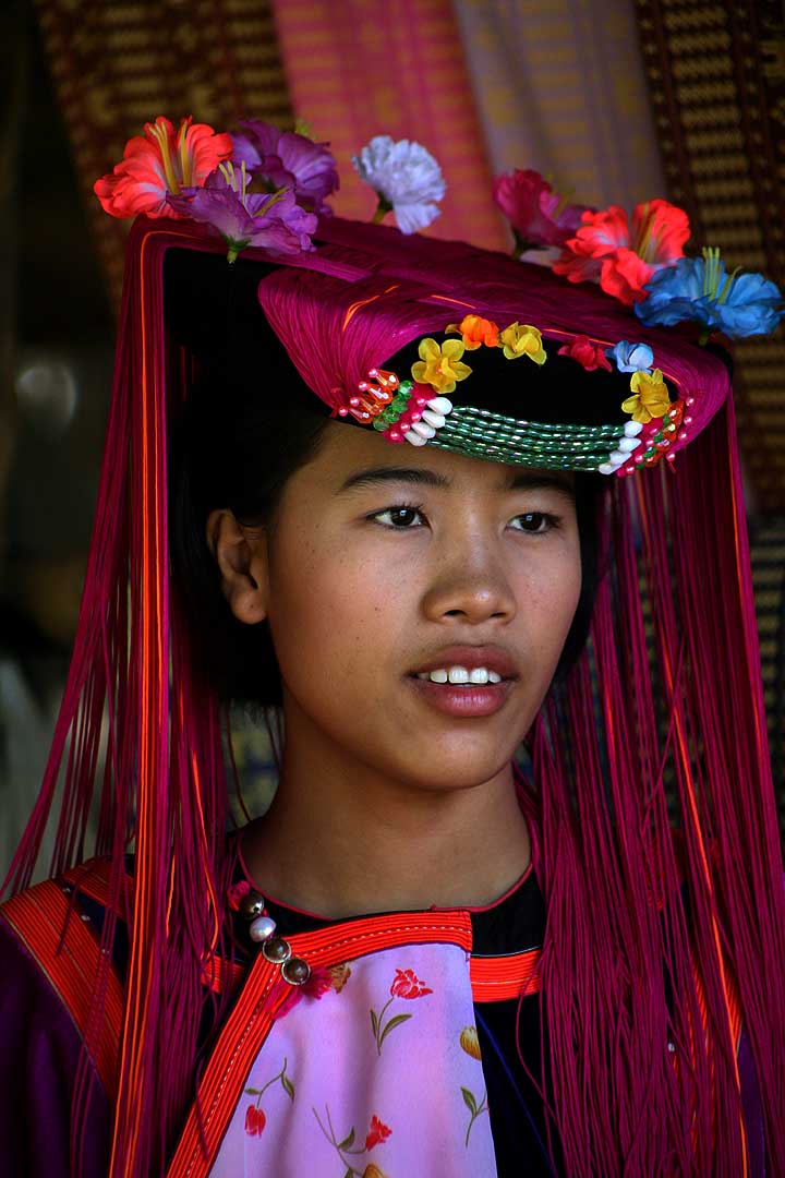

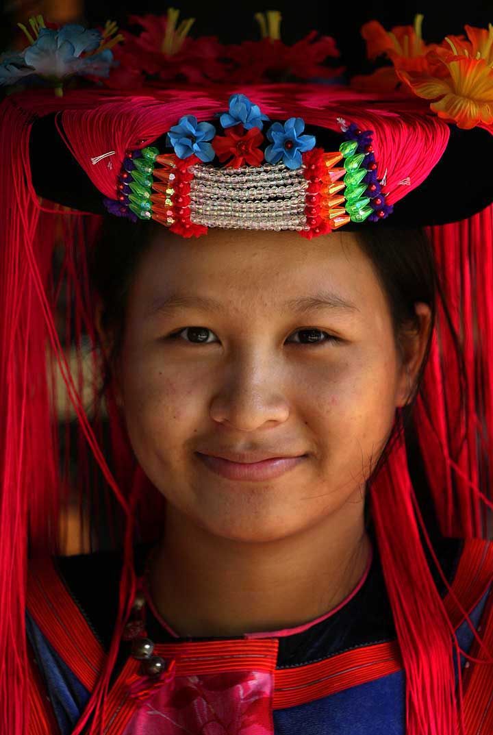
The Lisu people (Lisu: ꓡꓲ‐ꓢꓴ ꓫꓵꓽ; Burmese: လီဆူလူမျိုး, [lìsʰù]; Chinese: 傈僳族; pinyin: Lìsùzú; Thai: ลีสู่) are a Tibeto-Burman ethnic group who inhabit mountainous regions of Myanmar (Burma), southwest China, Thailand, and the Indian state of Arunachal Pradesh.
About 730,000 Lisu live in Lijiang, Baoshan, Nujiang, Dêqên and Dehong prefectures in Yunnan Province and Sichuan Province, China. The Lisu form one of the 56 ethnic groups officially recognized by China. In Myanmar, the Lisu are recognized as one of 135 ethnic groups and an estimated population of 600,000. Lisu live in the north of the country; Kachin State (Putao, Myitkyina, Danai, Waingmaw, Bhamo), Shan State (Momeik, Namhsan, Lashio, Hopang, and Kokang) and southern Shan State (Namsang, Loilem, Mongton), and Sagaing Division (Katha and Khamti), Mandalay Division (Mogok and Pyin Oo Lwin). Approximately 55,000 live in Thailand, where they are one of the six main hill tribes. They mainly inhabit remote mountainous areas. (Full article...)


Did you know (auto-generated) -

- ... that the Burmese and South Korean first ladies held their first informal conversation 44 years after the establishment of bilateral relations between the two countries?
- ... that clashes between the Myanmar military and local armed groups broke out in Lay Kay Kaw six years after it was established as a "town of peace" between the parties?
- ... that as part of the coronation of Mindon Min, the square yuzana around the capital was designated a sanctuary?
- ... that Rolling Stone named Mission of Burma's "Academy Fight Song" as one of the 100 greatest debut singles of all time?
- ... that the talabaw soup, which consists primarily of bamboo shoots, is the essential dish of Myanmar's Karen people, who use it to supplement rice?
- ... that former Burmese actress Honey Nway Oo turned rebel and took up arms against the military junta following the 2021 Myanmar coup d'état?
- ... that Thinzar Shunlei Yi hid in the Burmese jungle for a month and joined a rebel militia following the 2021 Myanmar coup d'état?
- ... that Aung Myo Min, Union Minister of Human Rights for the National Unity Government of Myanmar, is the country's first openly LGBT minister?
Related portals and projects
General images -
-
 Portuguese ruler and soldiers mounting an Elephant. Philips, Jan Caspar (draughtsman and engraver) (from History of Myanmar)
 -
 A theatrical performance of the Mon dance (from Culture of Myanmar)
 -
 Protesters in Yangon carrying signs reading "Free Daw Aung San Suu Kyi" on 8 February 2021. (from History of Myanmar)
 -
 Sculpture of Myanmar mythical lion (from Culture of Myanmar)
 -
 Former US President Barack Obama poses barefoot on the grounds of Shwedagon Pagoda, one of Myanmar's major Buddhist pilgrimage sites. (from Culture of Myanmar)
 -
 Hlei pyaingbwè - a Burmese regatta (from Culture of Myanmar)
 -
 Aerial view of a burned Rohingya village in Rakhine state, Myanmar, September 2017 (from History of Myanmar)
 -
 A large fracture on the Mingun Pahtodawgyi caused by the 1839 Ava earthquake. (from Geography of Myanmar)
 -
 Pagan Kingdom during Narapatisithu's reign. Burmese chronicles also claim Kengtung and Chiang Mai. Core areas shown in darker yellow. Peripheral areas in light yellow. Pagan incorporated key ports of Lower Burma into its core administration by the 13th century. (from History of Myanmar)
 -

-
 Protesters in Yangon with a banner that reads non-violence: national movement in Burmese, in the background is Shwedagon Pagoda. (from History of Myanmar)
 -
 Salween river at Mae Sam Laep on the Thai-Myanmar border (from Geography of Myanmar)
 -
 Recorder's Court on Sule Pagoda Road, with the Sule Pagoda at the far end, Rangoon, 1868. Photographer: J. Jackson. (from History of Myanmar)
 -
 A group of Buddhist worshipers at Shwedagon Pagoda, an important religious site for Burmese Buddhists (from Culture of Myanmar)
 -
 British soldiers remove their shoes at the entrance of Shwedagon Pagoda. To the left, a sign reads "Foot wearing is strictly prohibited" in Burmese, English, Tamil, and Urdu. (from Culture of Myanmar)
 -
 The paddle steamer Ramapoora (right) of the British India Steam Navigation Company on the Rangoon river having just arrived from Moulmein. 1895. Photographers: Watts and Skeen (from History of Myanmar)
 -
 British soldiers on patrol in the ruins of the Burmese town of Bahe during the advance on Mandalay, January 1945. (from History of Myanmar)
 -
 Myinhkin thabin - equestrian sport (from Culture of Myanmar)
 -
 Jade Mine in Hpakant (from Geography of Myanmar)
 -

-
 Myanmar (Burma) map of Köppen climate classification (from Geography of Myanmar)
 -
 The shores of Irrawaddy River at Nyaung-U, Bagan (from Geography of Myanmar)
 -
 Aung San Suu Kyi addresses crowds at the NLD headquarters shortly after her release. (from History of Myanmar)
 -
 Temples at Mrauk U, was the capital of the Mrauk U Kingdom, which ruled over what is now Rakhine State. (from History of Myanmar)
 -
 19th-century funeral cart and spire, which would form part of the procession from the home to the place of cremation (from Culture of Myanmar)
 -
 British soldiers dismantling cannons belonging to King Thibaw's forces, Third Anglo-Burmese War, Ava, 27 November 1885. Photographer: Hooper, Willoughby Wallace (1837–1912). (from History of Myanmar)
 -
 A wedding procession, with the groom and bride dressed in traditional Burmese wedding clothes, reminiscent of royal attire (from Culture of Myanmar)
 -

-
 Political Map of Burma (Myanmar) c. 1450 CE. (from History of Myanmar)
 -
 A wide range of Burmese lacquerware from Bagan (from Culture of Myanmar)
 -
 Grandfather Island, Dawei (from Geography of Myanmar)
 -
 Mountains near Pindaya on the Shan Plateau (from Geography of Myanmar)
 -

-
 Saint Mary's Cathedral in Downtown Yangon is the largest Roman Catholic cathedral in Burma. (from Culture of Myanmar)
 -
 A bull fight, 19th-century watercolour (from Culture of Myanmar)
 -
 The restored Taungoo or Nyaungyan dynasty c. 1650 CE. (from History of Myanmar)
 -
 Boxing match, 19th-century watercolour (from Culture of Myanmar)
 -
 Mount Popa, a dormant volcano in the Central Lowlands (from Geography of Myanmar)
 -
 Two female musicians play the saung at a performance in Mandalay. (from Culture of Myanmar)
 -
 Vegetable stall on the roadside at the Madras Lancer Lines, Mandalay, January 1886. Photographer: Hooper, Willoughby Wallace (1837–1912). (from History of Myanmar)


_headquarter.jpg)


Major topics
Categories

More topics

Associated Wikimedia
The following Wikimedia Foundation sister projects provide more on this subject:
-
 Commons
Free media repository -
 Wikibooks
Free textbooks and manuals -
 Wikidata
Free knowledge base -
 Wikinews
Free-content news -
 Wikiquote
Collection of quotations -
 Wikisource
Free-content library -
 Wikiversity
Free learning tools -
 Wikivoyage
Free travel guide -
 Wiktionary
Dictionary and thesaurus


