
Sugarloaf Mountain (Maine)
| Sugarloaf Mountain | |
|---|---|
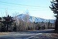
 Sugarloaf Mountain seen from the AT above Crocker Cirque | |
| Highest point | |
| Elevation | 4,226 ft (1,288 m)[1] |
| Prominence | 3,168 ft (966 m)[2] |
| Listing | |
| Coordinates | 45°01′54″N 70°18′48″W / 45.0316808°N 70.3133295°W[1] |
| Geography | |
 Sugarloaf Mountain | |
| Parent range | Rangeley-Stratton |
| Topo map | USGS Sugarloaf Mountain |
Sugarloaf Mountain is a ski mountain located in Carrabassett Valley, Franklin County, Maine. It is the third highest peak in the state, after Mount Katahdin's Baxter and Hamlin peaks. Sugarloaf is flanked to the south by Spaulding Mountain.
The northeast and west sides of Sugarloaf drain into the South Branch of the Carrabassett River, which flows into the Kennebec River, and into the Gulf of Maine. The southeast side of Sugarloaf drains into Rapid Stream, then into the West Branch of the Carrabassett River.
The Appalachian Trail (AT), a 2,170 mi (3,490 km) National Scenic Trail from Georgia to Maine, passes within a mile of the summit, skirting the peak to the west, and the summit is reached by a 0.6 mi (0.97 km) side trail. This side trail, and a trail down the east side of Sugarloaf, were originally part of the AT, which has been relocated down the north side of the mountain to the west of the ski slopes. Sugarloaf, a major ski resort is located on the north side of the mountain.
Gallery[edit]
-
 Sugarloaf Mountain ski runs
 -
 View from Sugarloaf summit
 -


See also[edit]
References[edit]
- ^ a b "Sugarloaf Mountain". Geographic Names Information System. United States Geological Survey, United States Department of the Interior. Retrieved 2024-05-21.
- ^ a b "Sugarloaf Mountain, Maine". Peakbagger.com. Retrieved 2024-05-21.
- ^ "New England Fifty Finest". Peakbagger.com. Retrieved 2024-05-21.
External links[edit]
This Maine state location article is a stub. You can help Wikipedia by expanding it. |